Brian G Smith
GIS Portfolio
Recipient of a fresh Certificate in Geographic Information Systems, June 2025. I am pursing an Internship or Full Time position.
You may notice in the following samples of my work that I have a Passion for Parks!


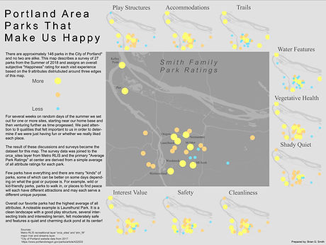
Park Ratings
This mapping project shows how my kids and I rated several Portland area parks for 9 attributes that we think are important. Each individual attribute was rated and is depicted in small multiples around the edge of the map. The central main map depicts the overall rating of each park as calculated by a formula in the attribute table.
Stealth Camping - Living in Parks
This project was a suitability analysis for best Portland Parks to live in. Given proximity to trails and railroads, which parks are sufficiently connected for travel between other parks that have restrooms and fresh water available. Out of those parks, a geodesic viewshed analysis was executed to determine where the terrain could accommodate staying out of view of streets within 1/2 mile.

Deaths in National Parks
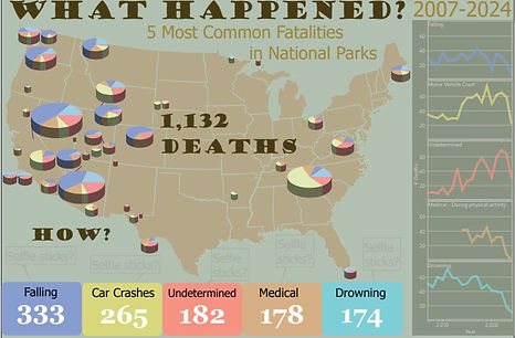
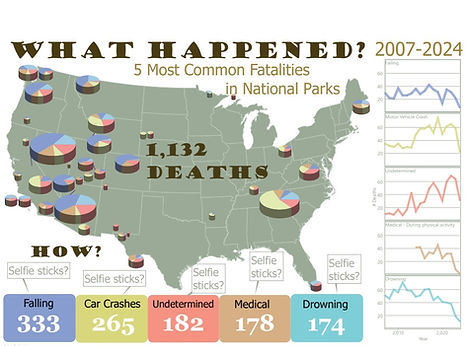
For this cartographic infographic, I collected casualty data from the National Park Service which spans the period 2007 to 2024. The data includes which National Parks and the Cause of Death. The legend at the bottom depicts the number of deaths over the entire time frame for the Top 5 most common causes. On the map itself, pie charts show both the relative proportion of deaths by size, and the proportion of each cause by color corresponding to the legend.
Finally, the color coded charts on the right side show the counts per year over the time period..
I played around with a few color schemes, and most of my peer reviews preferred this 'Green US on White Background' for my final version.

Crater Lake National Park Visitor Map
I conceived this map of Crater Lake to remind visitors to the Ranger's office or Visitor Center of the potential hazards of being in the park. The message is clear; have fun but consider the potential dangers. The callout at top includes the symbology for aid or contact stations which are located at various places around the lake perimeter.
